For European mapmakers in the late Middle Ages, the West Coast of Canada remained the last blank spot in the map, the world’s ultimate backwater.
The B.C. Archive’s prized 1696 world map, printed for the future king of France, shows continents and oceans similar to what you might see on Google Maps – except the western half of North America, where California remains an island, and points north dissolve into nothing.
“We knew the shape of Korea, Japan, China, even Australia, but they were just getting a handle on us,” said Lorne Hammond, curator of history at the Royal B.C. Museum. “At that time the limit of knowledge is us. The west coast of B.C. is an unknown, imagined landscape.”
Penciling in that last gap of coastline helped usher in a picture of the modern world, at least from a European point of view. The long journey to get there is charted in a new exhibition at the RBCM, Envisioning the World: The First Printed Maps, 1472-1700.
The museum is displaying 30 of the world's oldest printed maps, as drawn from the private collection of Henry Wendt, a life-long collector of ancient maps, and in collaboration with the Sonoma County Museum.
The collection charts the evolution of the known geographic world, and reveals how people reconciled biblical theology, scientific thought and the world beyond the horizon.
“The first 300 years is the theologian view of the known world, and when they started to fill in the gaps,” Hammond says. “It was going from what was imagined, to religion, to myth and then to grid mathematics.”
The oldest printed map in the world, printed in 1450s in Germany but originally crafted in 150 B.C., is akin to a pie chart – Europe, Africa and Asia, neatly divided and surrounded by oceans, and linked to Noah’s three sons.
A number of world maps in the exhibit are based on the ancient work of Ptolemy, and found in the library of Alexandria during the Renaissance. A map printed in 1482 in Ulm, Germany, but conceived in 147 B.C., spans Africa, Europe and through the east to India and China.
An early innovator, Ptolemy employed a sophisticated use of latitude and longitude, and projections of a spherical earth onto a plane. Noah’s three sons reappear on a map by Ptolemy printed in Germany in 1493, as do creatures and monsters thought to exist in unexplored parts of the world.
A map from 1582 reveals a deeper understanding of the Earth's movement in space. At the north and south poles, cherubs push crank handles, suggesting the world spins on a axis. At the same time, it displays a popular, church inspired mythology of the unknown world.
“Cannibals and monsters show on the left-hand side, suggesting what might be found in the New World,” said Wendt, who gave the media a tour of his maps on Thursday. “If they’re not Christian, they must be monsters. It was basic logic (of the church)."
Generations of sailors, explorers, merchants and missionaries helped cartographers shape the known world, and the invention of printing presses in the 1450s spread consistent and artistically appealing maps to major cities in Europe and around the Mediterranean Sea.
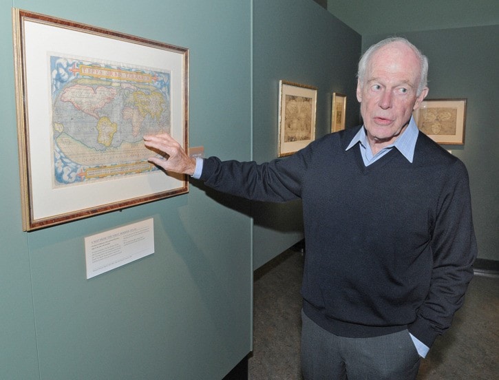
Wendt was quick to avow that his maps are “all my children,” but admits a favourite child is a 1570 map of the world by Abraham Ortelius, printed in the world’s first modern atlas.
Hand coloured, with exquisite detail, the map shows an enormous land mass in the southern hemisphere – labeled as Australia, an unknown land. This wasn’t based on surveys, but a kind of logic of the day. Scholars reckoned that for the Earth to rotate, it needed an equal amount of land in the southern hemisphere.
“Maps were limits of the imagination. If the Earth was spinning, there must be a counterweight to keep it spinning,” Hammond noted.
Wendt said rich and royal families typically purchased atlases and maps for educational purposes. “They put them on the library shelves, stacked other books on them, forgot about them, and that’s how they came to be preserved for us.”
The B.C. Archive's 1696 world map from France (called the Sanson-Jaillot world map), which is included in the exhibition, shows a world just shy of discovering British Columbia, and one where maps are wielded as political tools. The French knew California wasn't an island, but printed it as such as a favour to Spain, which was in competition against England for colonial spoils.
“(For Spain) it was better to have California as an island, than have vague boundaries," Hammond said. “You see precision, uncertainly and vagueness. It’s almost a modern map, but not quite there yet."
The odd map out in the display, but no less intriguing, is the Peutinger Table, a comprehensive map of the Roman Empire, and the oldest road map in the world.
Sixteen feet long with eight segments, the map shows in detail the rest points and distances to all corners of the empire, from Rome to England to Constantinople and to India.
Finally, proof that all roads do lead to Rome.
Envisioning the World is at the RBCM until Jan. 27. The maps are featured in an audio tour.
editor@saanichnews.com